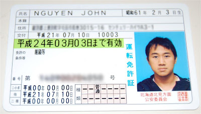
My international driver's permit is due to expire in a few weeks so I went during work today to get my Japanese Driver's license... and here it is!
Lucky for Canadian's, getting a Japanese license is super easy and just a matter of getting my Canadian driver's license translated, filling out a few forms, and paying around 7000 yen (unlike what my American friend Justin had to go through). w00t!


We made it back to the rushing river we crossed from the start of the hike (now a small creek at that altitude) where the new path meets back up with the old path. We continued up the creek, stepping from stone to stone, until we reached the rocky road to the top. We followed a path of loose stones through the trees for another hour until we cleared the trees and reached a giant mound of scree and boulders, like a scar on the face of the mountain. We scrambled our way to the top ridge and stopped to rest while we watched the clouds roil on the other side of the mountain. 

 |  |  |


 |  |
 |  |
 On a weekend in mid-May I went down to the Tulip Park to check out what all the fuss was about. I'd heard about the tulip fair before coming to Kamiyubetsu so I was eager to check it out. Right in the middle of the park is a wooden windmill that looks like it was lifted straight out of Holland with numerous rows of tulips strategically planted to create beautiful designs on the landscape. There are pavilions selling food and tulip-flavored omiyage (gifts), info booths about the city, a roofed cart giving guided tours through the park, a mini helicopter giving five minute aerial view rides, and needless to say, a lot of tulips! I walked around the park among the rows of flowers, checked out the information booths, had some tulip-flavored ice cream, and ran into a bunch of my students at the park before heading to the museum next to the park to chat a bit with the curator. The museum has a permanent exhibition on the native Ainu who lived in Hokkaido and on the Furusato soldiers who helped populate Eastern Hokkaido. The museum itself has some crazy concrete architecture that looks like something out of a sci-fi movie. If you weren't able to check out the fair this year, come by in the Spring next year! I'll still be here to show you around :)
So, I've given my blog a fresh, new look! One day while I was writing a post I looked at the page and realized how boring it was, so I brushed up on my ol' HTML skillz and installed in a new template. Too bad I haven't been posting as much!
Seriously though, writing blog posts are pretty time-consuming. I'm not one of those people skilled enough to write a polished post from scratch. First, I have to think of what to say, then I write it down, then I painstakingly go through what I've written a few times to edit and fix all the grammar errors. A short 3-4 paragraph post with 8-10 pictures can take me over an hour to publish and I usually have to be in the mood to write. So, apologies to you readers (the 4 of you) for nothing recent!
A few of the main reasons I keep this blog are to:
1) Let my friends and family back home know what I'm up to,
2) Improve my writing (considering I've only written one essay during my entire University degree), and most importantly:
3) Keep a journal of my time in Japan
I think a lot of us would love to remember all the things we've done or places we've been to in our lives. Some people keep journals, others keep picture albums; I keep a blog. Since arriving in Japan over 10 months ago, I've written 66 snippets of my experiences here and my travels to other countries. I think the greatest loss I could think of would be to lose these memories. If you think about it, everyone saves up money for two things: physical items and experiences. When you travel or see a movie or go to a concert, the experience itself is ephemeral but the memory of it lasts forever. It's the memories and experiences we're paying for, not the plane or concert tickets.
So anyways, that's why I write this blog. Sorry for all the rambling, I'm just thinking in my head.. out loud.. on the internet.. I'll get back to real posts again soon.
Huashan is one of those places, like the Great Wall, that can't be described in words but has to be experienced in person. As I was planning my trip to China I came across this photo:
It's one of those photo's that makes you think, "Wow, where is that?" I discovered it was an ancient mountain in central China called Huashan, and it was this photo more than anything else that made me decide to go to Xi'an.


 |  |  |
 I spent the next day exploring the rest of the peaks I hadn't visited yet. I went over to the East peak to see the morning sun reflecting brightly off the mountain walls. I walked over to see the lonely Chess Pavilion but decided not to pay it a visit due to the strong winds that day. When it was well into the afternoon I had visited all the peaks, walked up and down countless stairs, and walked almost every path that was on top of Huashan. I was tired, dirty, and exhausted so I decided to head back down. I opted for a quick 5 minute cable-car ride to the bottom because I wasn't quite up to tackle those stairs again. I fell asleep on the bus ride back to Xi'an that was stalled by engine troubles, heavy traffic and randomly stopping to pick up and drop people off on the side of the road.
 Later that night at the hostel, I looked through the pictures on my camera and wondered why I never saw that one photo that brought me to Huashan in the first place, those precarious planks of wood jutting out from the side of the mountain. After consulting the internet, I knew exactly where that photo was taken: it was in the one and only path I didn't bother trekking on, the one I came across just before the sun set and resolved to go back the next day to explore but didn't because I was too tired and decided to head down the mountain instead.. "F****CKK!" was all I could think once it hit me. "So that's what regret feels like!" I had the huge urge to head back to Huashan the next day just to hike that one last path, but my schedule and flight prevented me from doing so. I still have the urge to go back to Huashan one day to do that one path I missed but, apart from not seeing the photo that brought me there in the first place, I enjoyed my time on that beautiful mountain. Just having been there is good enough for me.
Check out my album for more pictures of Huashan.

About Me
Yubetsu, Hokkaido, Japan
John is in...
Friend's Blogs
-
Retirement8 years ago
-
いいっらしゃいませ!お元気ですか。14 years ago
-
Sparkle Motion *updated!*15 years ago


